
| NEBRASKA |
What’s interesting about a spire of soft rock standing, isolated, on the Great Northern Plains of America? Nothing unless you happen to be Chimney Rock which has served as a landmark for immigrants traveling in the Great Migration of the 1800s, a marker, a cemetery, and even a town in the Nebraska Panhandle.
Story by: Carianne White
Photography: Hawk Buckman

| GEOLOGY & HISTORY
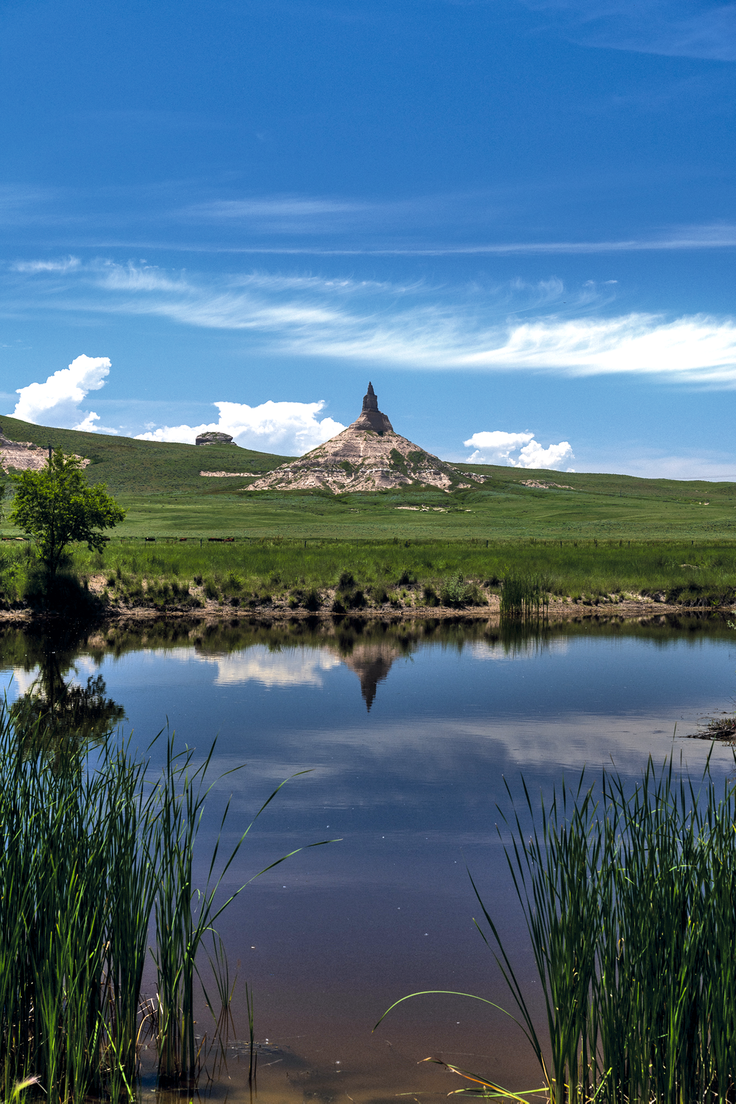
On the Great Western horizon of the Panhandle of Nebraska, the natural wonder of Chimney Rock stands, reaching toward the skies. At elevations measuring up to 4,225 feet above sea level in the late 1800s, during western migration, Chimney Rock was by far the most mentioned landmark in many of the traveler’s journals and writings.
Although no special events occurred at Chimney Rock, it was the most sought-after destination for many westward and eastward-bound Great Migration travelers. Some immigrants claimed that Chimney Rock could be seen from 30 to 40 miles away, and as they continued to travel toward the structure rising from the prairie, it always appeared to be off in the distance.

In the winter of 2021, writer Taylor Sheridan gave many of us a closer inside look of what it would be like to travel along the Oregon Trail as he introduced us to the TV Series “1883”. To avoid any spoilers for those who may not have seen the series, we are traveling along the Oregon Trail starting at Chimney Rock and into Wyoming in the eyes of a present-day traveler. The stories, history, and education on the Oregon Trail are immeasurable. Follow along with us as we take you on a short road trip that will expand your mind to a different time in history and introduce you to the WyoBraska section of the Oregon Trail.
Chimney Rock is known as a “Hoodoo, ” defined as a vertical stack of rock layers, with a major component containing volcanic ash and sand. The oldest layer of Chimney Rock dates to 34 million years ago and the youngest carbon dated to around 23 million years ago.
Massive volcanic eruptions occurred in what would become Nevada, Utah and Colorado 37 million years ago. The Great Plains of North America were covered in ash as the eruptions took over thousands of years.
Twenty million years ago, the continental seas began retreating. This new landscape was the forefather of the ancestral Great Plains. Uplift along the eastern margin of the Rocky Mountains was dramatic and staggering in power as it altered the landscape where deposits of the Cretaceous seas were raised thousands of feet above sea level, draining the waters into what would become the Gulf of Mexico.
| THE RISING ROCKY MOUNTAINS
To the east of the now-rising Rockies, gentle warping and uplift raised the former seabeds from one to a few thousand feet. The Black Hills, the Laramie Range, and the Hartville Uplift of eastern Wyoming were formed as highlands in the “Laramide Orogeny”. They reached maximum elevation in the late Paleocene and early Eocene.
Chimney Rock was formed in this erosion process as the soft layers of material were blown or washed away from the harder sedimentary rock transforming it into the monolith it is today.
Chimney Rock consists primarily of Brule clay inter-layered with volcanic ash and Arikaree sandstone which formed as the ash and sand compressed under the weight. Heat and pressure increased as silt and clay eventually covered the area of the Great Northern Plains for millions of years: turning most of central North America into a desert of blowing, drifting sand. Slowly top soils and vegetation covered the area in long grasses resilient to the colder aired climate.
Over the past 150 years, the spire of Chimney Rock has lost about 30 feet of height. Today, the summit of Chimney Rock rises 470 feet above the North Platte River Valley and measures 325 feet from the tip to the base.
In the mid to late 1800s the estimated height of the spire was just over 500 feet. Today the spire measures 120 feet. Wind, erosion, and repeated lightning strikes have contributed to the loss of height. Paintings by William Henry Jackson detail bull-whackers herding cattle along the Oregon Trail in 1892 in which he detailed Chimney Rock. Jackson’s watercolor painting depicts the monolith as almost twice its height today.


| THE LANDMARK OF A GENERATION
During the 1800s, Chimney Rock was one of the most noted landmarks along the immigrant trails. As travelers passed close to Chimney Rock, they said in their journals details of the structure and expressed relief that their wagon trains were traveling in the right direction as they inched along toward a new life in the west.
Some immigrants climbed to the top of the spire where they carved their names, or family names, into the soft rock, although few inscriptions survive today. Several would write in their journals that thousands of names were once placed upon the rock.
Chimney Rock has shared many nicknames by travelers of the past. Some Native American Tribes called it “The Teepee” or “The Wigwam” but the most interesting name for Chimney Rock was referred to by the Lakota Sioux referred to the unique formation of a term that meant “elk penis”.
Historians have proposed that the first non-natives to explore the pillar were probably Robert Stuart’s “Astorians” while traveling to the west coast of Oregon in 1813. Chimney Rock was mentioned in many immigrant diaries and journals in the following years after the Stuart expedition.
During the history of Chimney Rock, there was a small town named Chimney Rock that once stood near the base of the formation, and a post office was established in the village of Chimney Rock in 1913. The post office remained in operation until 1922.
Chimney Rock was designated a National Historic Site on August 9, 1956, and is a National Park Service-affiliated area maintained by The Nebraska Historical Society with the support of the National Park Service.


| MORE INFORMATION


